

Description
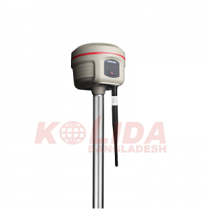
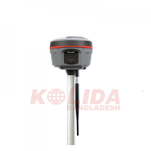
Kolida K20s RTK GNSS
More Advanced GNSS Engine
Kolida K20s RTK GNSS Featuring a powerful 692 channels GNSS mainboard inside, K20s can track and process all the existed satellite constellations. With the utility of the BEIDOU (COMPASS) signal, the data acquisition speed and GNSS signal stability are greatly improved from old generation technology.
10 Innovations to Increase Efficiency
More than 10 programs or functions were re-designed to make your workflow simpler and smoother, let you to work easier and comfortable, help you to get more reliable working results.
More Durable and Rugged
Kolida K20s RTK GNSS is fully sealed, has an IP 68 level proof. The built-in battery has 10,000 mAh capacity and can work 8 to 14 hours as an RTK rover, with only one recharge.
Work Safer and Easier
Thanks to the inertial measurement technology, K20s allows users to do a tilt survey with a maximum tilt angle of 60 °. Centring is not a must, so surveyors can stay in safe position when they measure on motorway and don’t need to step into the water.
Fast and accurate
Not like the tilt sensor, the Inertial Measurement Unit is no more affected by the earth’s magnetic field and requires no correction. It can be activated and start working within only few seconds, this fast positioning will increase measurement speed by over 30%.
The combination algorithm of IMU + GNSS can get fixed solution faster and keep measurement results more stable, accuracy is down to 2cm.
Measure where others can’t
Corner of the wall? Points underneath pipe? Points occupied by car? These targets are no more accessible..
Long Range Radio Link
With Kolida K20s RTK GNSS SDL400 built-in radio can send signals as far as 7 km in the urban areas, 8 km in suburban. The maximum coverage is up to 200 sq. km, suitable to have multiple rovers work simultaneously.
Barrier-Free Measurement
In a difficult environment, you may be lost connection with the base station or VRS network. Don’t be disappointed, you can choose from 3 creative work modes to continue surveying without interruption. (Repeater/ Router/ Mobile Refenrence Station)
Anti-interference
SDL400 built-in radio features anti-interference capability, so K20s can work close to the power plants, transformer substations, mobile signal towers and other interference source.
Practical Functions
K20s employs a Linux system, it helps surveyors to accomplish their missions easier, faster and more accurate by delivering exceptional quality and innovative features.

Reviews
There are no reviews yet.